 Click Photo for Larger Version
|
Image ToolbarPlease read before you download
Images and/or text from holylandphotos.org are NOT TO BE USED ON OTHER WEB SITES, NOR COMMERCIALLY, without special permission. To request permission contact us at holylandphotos@gmail.com. |
View of a portion of the flat tableland that stretches northward from the Arnon to the Heshbon region (NIV; Heb. mishor; see, e.g., Deut 3:10; Josh 13:9, 16). This region was given over to growing grain crops and the raising of sheep.
This picture was taken in early July when the sheep and goats were feeding on the areas of the harvested fields.
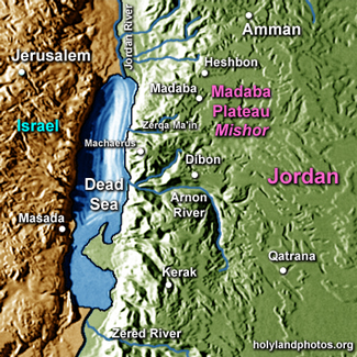 Because of the lower elevations, rainfall in the Mishor region approaches only 10 inches annually. Throughout Moab the major agricultural crops were wheat and barley, and sheep breeding was a major source of revenue. Mesha, the king of Moab, is reported to have supplied the king of Israel with 100,000 lambs and the wool of 100,000 rams (2 Kings 3:4).
The Israelite tribes of Reuben and Gad were allotted cities in the plateau region (e.g., Num 32; Josh 13:15 – 28). But it was the Moabites who usually fought with Israel for control of the region during the period of the divided monarchy (931 – 722 BC).
Image from the Zondervan Atlas of the Bible, p. 61.